Showing posts with label Mount Rainier. Show all posts

Wednesday, October 12, 2016

Eight Times Around Rainier

Eight Times Around Rainier:
Wandering the Wonderland in Ceaseless Wonder

photo by Ras/UltraPedestrian.comBy Kathy Vaughan

     We awoke in the middle of the trail, the cold pre-dawn chilling us until we stirred fitfully. We were on the descent to the South Mowich River from Golden Lakes. We had hiked through the high alpine meadows and the area around the old patrol cabin in the middle of the night, frost on the boardwalks and puncheon bridges crunching underfoot. The silvered and burned snags stood tall in the distance as we moved towards them, knowing that we would soon be descending towards the Mowich, the wooded switchback trails ahead giving us an opportunity to catch a couple hour nap. 

     Ras and I were on a nighttime stretch during our 94 mile Wonderland Trail run around Mt. Rainer. We had a long weekend open up in the midst of our busy schedule working as weeders for a yard care service on Whidbey Island. Each weekend all summer long, Ras and I had been getting out on adventure runs, either with each other or with other partners. This was an opportunity for us to do something long together. It would be a challenge and I didn’t know if all of my unsupported trail excursions would benefit me on the 20,000+ feet of elevation gain involved in this circumambulation of Rainier, or hinder me because of my sore knees and tight IT bands. I had set out in an attempt to run the Wonderland on the weekend of my 50th birthday, with my friend Lisa. It was quite hot on the trails around the mountain that weekend, and we altered our route to the 40 mile Owyhigh Lakes loop instead. I was crawling along slowly on the climbs in the heat, and may have even been suffering from some heat illness. The Wonderland wasn’t going to work for me that weekend, but this weekend, with the first of the autumn temperatures on the mountain scape, it was seeming more likely.

photo by Ras/UltraPedestrian.com

     Ras and I set out from Longmire at 10:33 in the morning on Saturday the 6th of September. We headed out clockwise to tackle the 10,000 feet of elevation gain we would encounter on the more secluded west side of Rainier. We started by climbing towards Rampart Ridge, crossing the glacial waters of Kautz Creek and then onwards towards Pyramid Creek. The going in here was smooth and encouraging. I enjoyed the cooler weather and was prepared with enough layers to take on colder temperatures as they were likely to occur when the sun dropped. I love the fall and spending time in the forest on cool days is an all sensory experience. The damp earth emits a woodsy fragrance that brings me calm and evokes feelings of peace from past trail times. 

     Ras and I each settled into our own thoughts and quietly pushed the climb towards Devil’s Dream Camp and Indian Henry’s Hunting ground beyond. The patrol cabin there was occupied with other people out enjoying the trail, so Ras and I continued on before taking our first sit down break.  We had brought along our leftovers from Pizza Pi all vegan pizzeria in the U district of Seattle.  We used to take our daughter Angela there when she attended the University of Washington. We purposely got enough so that we would have some for the trail, a special way to take in some calories and good memories at the same time. My favorite is Presto Pesto and I shared some slices with Ras, as we sat alongside the trail where it first descends from the high meadows of Indian Henry’s Hunting grounds towards the suspension bridge that spans Tahoma Creek, far below. 

     We got chilled pretty fast and this forced us to get moving on our technical descent to the bridge. The trail was steep and rocky, but also scenic and fun. We got moving and reached the bridge in no time. It was fun to cross and think about my first time, crossing it together with Angela as she was only 7 and needed accompaniment. Ras shot some video on our crossings and we continued on our way, climbing towards Emerald Ridge. Nothing about the Wonderland is easy. There are challenges all along the way. Each seemingly insurmountable challenge I’ve ever experienced on that route has taught me a valuable lesson; has been achievable; has been worth every minute of it. All moments in the raw wild of nature are what is real about life. It’s the moments indoors, eating processed food and being warmed by unnatural heating that are artificial. I thrive in the outdoors. I spend time indoors and even time working in the outdoors, longing for the freedom of the trails. 

photo by Ras/UltraPedestrian.com

     Being on the Wonderland and having 94 miles to cover, I was in my element. Any struggles aside, I was in a zone out of which I could not be snapped until I returned to my car, on foot.  I had set out to complete this once already a few weeks back. This time I would cover all the miles, see all the sights, feel all the feels of completing this iconic route in one straight through push.

     Mist rising off of the wet downed old growth created a mystical feel to the surroundings as Ras and I were waking up. We had to get across a couple of separate channels of the braided Mowich Rivers coming off of the glacier on this facing of the mountain. The river was wild and tumultuous; the color of chocolate milk. Ras had tried to build a rock crossing here in the middle of his Rainier Infinity Loop in July. He finally spotted a log crossing with his partner Gavin Woody and got safely across. We didn’t know what to expect this time because of the experience he had earlier in the season. 

photo by Ras/UltraPedestrian.com

     Instead, there had been a new bridge built and easy to follow cairns marking the way through the rocky river bed. We got across without issue and soon saw a young couple, also doing the Wonderland in ultrarunner style. They were coming downhill, moving well, and looked like they had been working hard. They may have even looked “too fresh”, and Ras and I surmised their run may have been supported. They might have camped up at Mowich Lake the night before. They may have just been younger, stronger, more fit and rocking it in better style than Ras and I too. Either way, they were friendly. We went on our way, climbing up from the Mowich crossings toward the eponymous lake.

photo by Kathy Vaughan/UltraPedestrian.com

       I have done this climb so many times and in a different mode each time. On this occasion I felt pretty strong, although it does always feel relentless. It’s a 3.7 mile climb with a 1,000 foot gain per mile. That’s stiff. I listened to some good music on my mp3 player to distract me. I settled into the switchbacks. Ras and I paused for a few minutes and had a snack. We continued on contouring at first and then climbing gently towards some creek crossings. Onwards, upwards towards Mowich Lake where Ras planned on checking the thru hiker box at the ranger cabin. I had hoped he would find some hand warmers there, or any kind of vegan friendly snack food. We were “thruing” the Wonderland, after all, and it was legit to see what the hiker box might behold. We’ve contributed to these things before.

      I sat at a picnic table, cleaning out and reorganizing my pack, as I watched the comings and goings of the camp area. I felt drowsy and low energy, but looked forward to the 2ish mile climb to Ipsut Pass. Once there, we had a long descent to the confluence of Ipsut Creek and the Carbon River. This was a magically scenic section of trail through thick old growth forest with babbling brooks, gigantic ferns and soft carpets of differing mosses. We could make some good time in here and relax into the day. 

photo by Kathy Vaughan/UltraPedestrian.com

     Ras returned with a small baggie of Starbursts, which we divided up evenly. I ate mine right there and threw the little wrappers away while we had access to garbage cans. We got ready and hit the trail once again. The trail left the lakeshore and made its way to the pass where several other parties arrived at the exact same time that we did. We let two guys go ahead of us on the down climb and then we left the scenic over look to descend into the Ipsut Creek drainage. It is one of the most beautiful spots on earth and I love being there. I watched my footing while still taking in the views. There were also berries to eat and Ras dropped behind to graze. I was enjoying trotting along on the steep switchbacks, knowing that the evening’s mileage included climbing the rocky trail along the Carbon Glacier, past Dick Creek Camp, through Moraine Park to the high ridge above Mystic Lake.

photo by Kathy Vaughan/UltraPedestrian.com

     The mountain reappeared as the enchanted, wooded meadow of Moraine Park opened into a valley dotted with large erratics. Marmots whistled in the distance. My goal was to reach that ridge above Mystic Lake before the sun sunk and we lost our light. I climbed in earnest, my eyes searching for the ridge after each steep, short switchback. Leading the climb, with Ras just behind me, I got to the sign pointing to the lake .7 miles away, at the high point I’d had in my sights. It felt good to have reached that little goal. I called out in triumph to Ras, but kept on going, trying to run some of this downhill, my headlamp leading the way now. It was an eroded and steep trail for a little way, but then it ended in a sweet little flat meadow leading up to the lake. It then ran alongside the lake. Being here in the dark was absolutely perfect.

photo by Ras/UltraPedestrian.com

     After running around a portion of the lake, the trail took us off towards the camp. We stopped so I could get some little rocks out of my shoes and Ras got a couple of pictures from this spot at the alpine lake in the quiet of the night. We got through the camp unnoticed and went on our way to cross White River, another of the glacial river crossings. This one was as smooth as the others had been, a good log crossing in place. Now the trail was cruisy as we meandered along with only gentle climbs, leading to the moraine field section. Going through this exposed section at night felt good, cold drifts of air coming up from the openings between the huge rocks in this glacial wasteland.  There is no shade in here if traveling in the heat of the day during the summer months. Ras and I made good time through this section and then we had another river to cross.

photo by Ras/UltraPedestrian.com

     Winthrop Creek at 4,900 feet originates from the second largest glacier on the mountain and is named after Theodore Winthrop, a nineteenth century author. In 1853 he saw the Winthrop Glacier and writes about it in his book “The Canoe and The Saddle”. We crossed the creek via a sturdy log. On the other side, we began a steep climb. We passed a spot where Garda Falls once attracted hikers for camping. It then closed to camping and was a water stop for my family many times. But late one night while running the Mother Mountain Loop with my friends Vivian Doorn and Lisa Eversgerd, we got to this spot, and it no longer existed. I had told them we could stop here and get water before the climb, but it had been obliterated in a land slide. A large tree jam had changed the terrain and it was no longer a parked-out rest stop. It was uninviting, sharp branches poking out and piled up on each other. We had moved on.

     Ras and I did not speak of this as we passed through this time around. It had gotten dark again, another night coming to pass. We were focused on getting to the White River Campground where we planned on taking a nap at the thru-hikers’ camp site. We had some miles to cover before then, but we knew how to get it done. We both had our mp3 players going, giving us something to enjoy listening to as we traveled along the trail through the dark of the night. We were moving towards Granite Creek Camp at 5,730 feet. This was another favorite spot along the trail, because the creek itself is so clean and pure, such a classic example of a mountain stream. My family took a rest day at the group site here when we first took on this trail with Angela at age seven, a big eyed innocent young hiker. She loved meeting other hikers and she got to interact with some at the camp during that hike. We hung out in camp all day, playing at the stream some and washing our clothes in a large ziplock bag.

     But this time, Ras and I crossed the small log foot bridge and moved through yet another of the Wonderland camps stealthily under the night sky. We now had some gentle switchbacks for a couple of miles until reaching the high open landscape of Packtrain Ridge. I had been struggling internally with the effort we were putting out. I was disoriented and slightly out of it when we first got up onto the ridge. There was thick mist in the air and it was hard to see very far in front of us. Ras had taken the lead, feeling good and moving well. I struggled behind him with these feelings of not quite vertigo, but something taking over my whole being, my state of mind and my ability to move very efficiently this late in the night. I really did know this area of the trail quite well. But right now, I could not figure out where we were. We finally reached the intersection where the trail to Skyscraper Peak stretches off towards the sky. Ras said, “Okay, are you ready?” I was in disbelief. I didn’t know if I could even pull off the rest of the mileage to complete the Wonderland, let alone add on this side trip to climb Skyscraper. He said we had decided even just a short while ago that we would climb it. I had no recollection of that and was really surprised that he had planned on doing it. It was midnight, cold, and we were already pressed for enough time to finish and get back to work by nine o’clock Tuesday morning. 

     Unfortunately, this ended up being a turning point for me. I knew I had disappointed Ras by turning down the side trip up Skyscraper. I like the climb too. I too was enjoying making summits each weekend throughout the summer. At this moment though, I felt like adding it onto our 94 mile adventure that was stretching out, was over the top. I also felt pulled to do it and was bummed out I had reacted so strongly to the idea. It did not feel good that we were now moving on, down the trail, in the thick mist, away from the opportunity to pull off that summit. I got teary and even more weary. We dropped down towards Sunrise Camp in the cold basin below us. Ras stayed in the lead. We tried stopping in the lee of an outbuilding at the camp, but the strong wind gusts were still too cold for us to stop for long. We moved on, now on the final three mile stretch towards White River Camp and our nap.

     Finally, we got to the wooded camp. There were restrooms and spigots with running water. We put down one of our Six Moon Designs Gatewood Capes and used the other for a cover. We bundled up in every layer we had with down puffy suits as the top layer. I took off my Altra Lone Peak 3.0 NeoShell Mids, and Ras kept his Lone Peaks on his feet for warmth. I had a blister and wanted to stretch out my feet. It felt good to be out of shoes for a little while. It was 4:30 in the morning. We both fell fast asleep, surrounded by other thru-hikers, unaware of our presence in camp right near them.

     We wanted to wake up and exit the area to begin our final 30 miles, by about 7:30, allowing us three hours of sleep. I woke up first and wondered off to the rest rooms, filling my water bottles on the way back. Ras was still asleep, so I cuddled up beside him and rested just a little longer. We didn’t discuss our plan for the day. I really didn’t know yet what it was. I encouraged him to wake up and move out to the picnic area where we could find a sunny spot to warm up and regroup. We finally moved out there, but were both so tired we would drop off to sleep in the sunshine before making any progress with our trip planning. Could I continue? Did we have enough time? Should we hitchhike back to Longmire from here? Should we pull ourselves together and just get back out on the trail? Would we make it to work on time if we continued? Could we even contact our boss, Mary, from here via our cell phones? 

     After moving from sunny spot to sunny spot for a couple of hours, taking in mouthfuls of my Expedition Espresso Trail Butter pouch to energize myself, we finally argued ourselves into getting started again. Neither of us wanted to give up and we knew we could finish off the mileage. We just didn’t know if we could pick up the pace like we needed to, this deep in.  I had a couple of blisters I needed to tend to before getting started and I’d have to push myself to run more than hike in order to get this thing done. 

photo by Ras/UltraPedestrian.com

     We hit the trail leading out of the White River Campground, crossed the White River and ran the rolling trail for several miles before it began the climb along Frying Pan Creek. We moved together quietly. I knew that each time I pushed myself harder than I felt like I could, harder than I wanted to, it would make a difference. This was it. These were the final miles of the Wonderland Trail. Before I knew it, we had reached the high meadows of Summerland and began our trek up the steps towards Panhandle Gap. We were at one of the final cruxes of the route. This climb through snowfields in the cold mist and wind was hard. We couldn’t stop as it was just too cold. We were low on food, stretching out carefully what we had left to last into the night miles. The views were not far reaching. The clouds and thick mists shielded the views from us as we looked out into the distance. We both pushed forward, strong and determined. At the Ohanepecosh River we would take a break and fill our water bottles. Right now we just wanted to move, one foot in front of the other, through this mountainous terrain. 

photo by Kathy Vaughan/UltraPedestrian.com

     A few other backpackers meandered through the camp at Indian Bar. They were filtering water, or getting settled into camp, or just relaxing after a day on the trail. We were filtering water and then moving on, an additional 18 miles to go before finishing our weekend route. Nothing is as scenic as Indian Bar. The Ohanepecosh River meanders down from an inactive hanging glacier and babbles through the valley. A stone shelter presides just above the river and the hidden backcountry camp turns off the trail just before it.  Ras and I settled into a spot were a side creek splits off from the main river and it’s easy to get nice clear water here. We shared Honey Stinger Energy Chews and drank ice cold water. We knew we had it now. The Cowlitz Divide lay ahead. This would be challenging, steep little climbs and descents over eight miles or so. Then, before we knew it, we would be running the gentle downhill trail towards Nickle Creek. I was looking forward to passing the intersection of trail where Lisa and I decided to run the Owyhigh Lakes Loop instead of the Wonderland for my 50th, back in August. It was a hard decision and we sat at that spot for a good half hour. I knew it would feel pretty awesome to run through it, on my way to completing the Wonderland this summer after all. 

photo by Kathy Vaughan/UltraPedestrian.com

     Ras and I felt great moving through the Cowlitz Divide. We took a couple of short breaks on scenic overlooks, but for the most part, got some quick miles in. We climbed well and had those little summits behind us before we knew it. I recognized the point where the trail begins to descend towards Nickle Creek. I opened up and let loose. I ran well and the miles glided by. We got to the intersection where Olallie Camp cuts off, where Lisa and I had turned. We ran by it and it did feel good. On and on we went at a good pace, running towards Nickle Creek, Box Canyon and then Maple Creek. 

     Somewhere around Maple Creek it all took a turn. Rain began to fall, at first as a drizzle which wasn’t much of an issue for us. It then came on stronger, and finally began pouring with an intensity that grew more mighty with each foot of elevation we gained. The night wore on and on, rain soaking us and only the end in sight pulling us like a magnet ever forward along the dark trail. We both wore our Gatewood Capes and they kept us warm and dry enough, if we kept moving. We could completely tuck underneath it if we needed to make an adjustment with our mp3 players, headlamps or wrappers on our snacks. Ras knew I was running a little low on my food supply, so he had saved a Caramel Honey Stinger Waffle for me. It tasted so good, in this nighttime rain storm, almost 90 miles into the Wonderland.

     Ras shared stories with me about what it was like for he and Gavin at this point in their Rainier Infinity Loop. They finished it at Paradise and thus had to climb an additional 3,000 feet in three miles off of the Wonderland route. They had already summited Rainier twice at this same point we were tackling in the night. Stevens Canyon was wet, slick, steep, but well maintained. A trail crew had been through and cut back all of the thick brush that tends to cover the trail in here. It had been that way when Ras and Gavin came through here. The workers had also repaired a slide in a section prone to giving way, and so we had a safe passage through here as well. 

photo by Kathy Vaughan/UltraPedestrian.com

     The climb ended at Reflection Lakes. The trail crosses the Stevens Canyon Highway at a couple of different points, circles the outer edge of Lake Louise and climbs again to reach Reflection Lakes. Then finally, the descent to Longmire begins. Ras and I had a couple of hours to go before our circle around the mountain was complete. We were able to run, albeit slowly, along the Paradise River. The trail had roots and rocks to navigate. They were wet from the deluge, but Ras took the lead here and we were each able to skip through at our own comfortable pace.  

     I could hear the roar of the Nisqually River, the final glacial river crossing. Nicely built log crossings with rails were in place, so getting across all of the channels was easy enough, even in the dark. It seemed now like most of our glacial river crossings had been in the dark. I reflected on how far I had come with these crossings. I once felt so nervous, sometimes crying or jittering with fear as I heard the loud rushing of the silty waters. Now, it was just not a big deal and my body did not send me these same signals.

     From the Nisqually, Cougar Rock Campground is just a short distance away. Car campers can drive up to this campground and hikers can also reserve spots to utilize it during a thru hike of the Wonderland. We quietly ran past the spur trail leading to the campground and continued down the wide path lined in huge firs, cedars and hemlocks. We could see the remains of old wooden water pipes that were once used to transport water in this area. We knew we were getting closer, but we still had just shy of two miles to go. 

     The bright lights of Longmire let us know we were there. I picked up the pace, running the easy final stretch of trail into the well-lit parking lot. It was 3:30 a.m. Ras and I had taken 65 hours to run and hike the Wonderland Trail, unsupported, with autumn temperatures and daylight guiding our way.  We got to our old Subaru wagon and took off our Nathan packs. I climbed into the front seat and reached for my bag of dry clothes I’d been visualizing changing into for many wet hours. Although wet, my feet had been well protected and warm inside my Altra Lone Peak 3.0  NeoShell Mids. My gear was dry inside my Nathan running vest. I felt good inside, having stuck to an ethic of Zero Limits and completed my eighth and fastest circumambulation of Mount Rainier.  

photo by Ras/UltraPedestrian.com


KATHY’S GEAR LIST

1. Nathan VaporShadow (I used the male version belonging to Ras, waiting for the arrival of my female version, the VaporAiress. I have since received two Nathan Ultrarunning packs, designed specifically for women, and used the VaporAiress for a supported 50k. I fell in love with this pack, finding it perfectly designed. It was so comfortable and had all the right pockets in all the right places. It was easy to reach the side zip pouches while still moving. I hardly noticed it for the eight hours I wore it, fresh off the shelf. Ras and I are now new, Nathan brand ambassadors.) 
2. Altra Lone Peak 3.0 NeoShell Mids 
3. Injinji Trail Socks
4. Altra Performance Skirt 
5. Altra tech short sleeve shirt
6. Smartwool mid weight hooded sweater, arm sleeves, knee high ski socks, calf sleeves and neck gaiter
7. Dirty Girl Gaiters
8. Six Moon Designs Gatewood Cape
9. Mammut Down Puffy Jacket 850 Fill
10. Mont Bell Down Puffy & synthetic blend pants
11. 3 packets of chemical handwarmers
12. Ziplock baggie of pancreatic enzymes, antacids, ibuprofen, caffeine pills, and ginger chews
13. Ziplock baggie of toilet paper and a moist towlette
14. 4 Honey Stinger Waffles, 1 packet of Honey Stinger Energy Chews, 2 avacado wraps in whole wheat tortillas, a baggie of roasted and salted seaweed snacks, 2 Expedition Expresso Trail Butter pouches, 4 Picky Bars, 4 slices of leftover vegan Presto Pesto pizza from Pizza Pi in Seattle, 1 homemade apricot fruit roll-up, a few peppermint hard candies, 1 package of Mushroom & Herb cous cous, rehydrated with cold water in a plastic ziplock container, a small serving of Ras’ dehydrated rice and beans.
15. Skins brand compression capris
16. The North Face brand heavy winter running tights
17. Mp3 player loaded with lots of Raggae Dancehall mixed tapes, The Martian and Dharma Bums
18. Black Diamond Icon Mountaineering headlamp with extra set of batteries
19. Smartphone, mainly for use as a camera
20. Swix brand cross country ski gloves
21. Fleece and synthetic fur lined ear flap hat   
*Ras carried 2 small chargers for recharging our electronic devices


photo by Kathy Vaughan/UltraPedestrian.com


Tuesday, August 9, 2016

Mount Rainier Infinity Loop - Caloric Burn Versus Intake

Complete Caloric Burn versus Intake
  
photo by Ras / UltraPedestrian.com

Mount Rainier Infinity Loop


Our Parks/Your Adventure Fundraiser for The Mountaineers Youth Programs - Ras Vaughan and Gavin Woody
                                                                     
by Ras Vaughan


RAS' COMPLETE CALORIE LIST FOR MOUNT RAINIER INFINITY LOOP:

Trail Calories

Honey Stinger Waffles 10 x 150 = 1,500 calories
Picky Bars Smooth Caffeinator 4 x 200 = 800 calories
Trail Butter Expedition Espresso 5 x 760 = 3,800 calories
Pringles Tangy Buffalo Wing 3 x 900 = 2,700 calories
Instant Korean Ginsing Tea 9 x 10 = 90 calories
Peanut Butter Crackers packet 3 x 200 = 600 calories
Granola Bar 1 x 190 = 190 calories
Honey Stinger Cherry Cola Energy Chews 5 x 160 = 800 calories
Honey Stinger Juneberry Protein Chews 1 x 150 = 150 calories
Kim Chee flavored Dried Seaweed Snacks 1 x 30 = 30 calories
Instant Oatmeal Packets calories 5 x 170 = 850 calories
Honey Stinger Peanut Butter & Jelly bar 1 x 170 = 170 calories
Honey Stinger Cran-Apple & Walnuts bar 1 x 150 = 150 calories
Honey Stinger Nuts, Seeds, & Roasted Serrano bar 1 x 200 = 200 calories
-----------------
12,030 total calories on trail


Calories at Resupply

Soon Vegetarian Noodle Soup 180 x 4 = 720
Stir-Fry vegetable mix 100 x 1 = 100
Energy drink 180 x 2 = 360
-----------------
1,180 total calories at resupply


Total calories consumed during Rainier Infinity Loop

12,030 total calories on trail
1,180 total calories at resupply
-----------------
13,210 total calories consumed


Caloric needs for Rainier Infinity Loop

120 miles x 100 calories per mile = 12,000 calories
40,000 feet elevation gain x 100 calories per 1,000 feet of gain = 4,000 calories
2,000 daily baseline metabolic calories x 4days = 8,000 calories
-----------------
24,000 total calories burned


Overall Caloric Burn Versus Intake for Rainier Infinity Loop

24,000 total calories burned
13,210 total calories consumed
-----------------

10,790 calories total caloric debt accrued – iViva fat fueling!


photo by Ras / UltraPedestrian.com

We hope to use this project to inspire future generations of climbers, runners, thru-hikers, fastpackers, backpackers, and adventurers of all stripes by helping raise money for The Mountaineers Youth Programs by means of the Our Parks / Your Adventure initiative. Please click here to learn more about the program and to donate. Whether you give $10 or $5,000 your donation will help introduce deserving young people to the fulfillment and enrichment of outdoor adventure, essentially helping to reintroduce them to their natural habitat.

photo by Ras / UltraPedestrian.com


Saturday, July 30, 2016

Complete Gear List Infinity Loop


Complete Gear List
  

Mount Rainier Infinity Loop


Our Parks/Your Adventure Fundraiser for The Mountaineers Youth Programs - Ras Vaughan and Gavin Woody
                                                                     
by Ras Vaughan

COMPLETE GEAR LIST FOR MOUNT RAINIER INFINITY LOOP:

One of the challenges I enjoy about hard to define multi-disciplinary adventures is gearing up and kitting out. Especially when there is a serious mountaineering element combined with high-mileage travel it's of the utmost importance to carry a minimal kit which is flexible enough to do everything you need it to do. On the Rainier Infinity Loop I was very happy with how this played out. 

Loop #1 starting pack weight: 24 lbs
Loop #2 starting pack weight: 20 lbs
Ending pack weight: 15 lbs

Here's a complete list of all the gear (non-food) I used:

Nathan Journey Fastpack (preproduction test model)
Nathan Insulated 750 ml bottles (2)
Nathan 2 Liter Bladder
Altra NeoShell Lone Peak insulated, waterproof trail running shoes
Altra Performance Half Zip Long Sleeve Shell 
Altra Racer Shorts
Altra Running Ambassador Shirt (1st loop)
Montbell synthetic puffy jacket
Western Mountaineering Flash Pant (didn't use)
Sugoi Insulated Running Tights
Injinji Trail 2.0 midweight toe socks
Smartwool midweight socks (2nd loop)
Smartwool Arm Warmers
Darn Tough wool socks (1st loop)
Seven Hills Running Shop shirt by Pearl Izumi (2nd loop)
Kahtoola KTS Steel Crampons
Julbo Glacier Glasses
Outdoor Research Expedition gaiters
Black Diamond Polar Icon Headlamp
Black Diamond gloves
Black Diamond Coulior Climbing Harness
DMM Big BOA Locking Carabiner (1)
DMM Revolver Locking Carabiner (2)
DMM Shadow Carabiner (1)
Metolius Prussiks (2)
Metolius 24" webbing sling
Bluewater 48" webbing sling
Camp Corsa Aluminum Ice Axe
Northwest Endurance Events buff
UltraPedestrian fleece beanie (didn't use)
REI merino wool liner gloves
Cheap Fleece camo hat bought in a mini mart years ago
Six Moons Designs Gatewood Cape, dropped at car after 1st loop
Trail Butter "Be Trail Ready" trucker cap
Not Pictured:
Black Diamond Ultra Distance Carbon Z Poles
Black Diamond Vapor Helmet
SPOT Transponder
Sony Walkman mp3 player
Asio Altimeter watch
BRS-3000T stove
Toaks 750ml titanium pot

We hope to use this project to inspire future generations of climbers, runners, thru-hikers, fastpackers, backpackers, and adventurers of all stripes by helping raise money for The Mountaineers Youth Programs by means of the Our Parks / Your Adventure initiative. Please click here to learn more about the program and to donate. Whether you give $10 or $5,000 your donation will help introduce deserving young people to the fulfillment and enrichment of outdoor adventure, essentially helping to reintroduce them to their natural habitat.


photo by Ras / UltraPedestrian.com

Rainier Infinity Loop Completed


Mount Rainier Infinity Loop Completed
Only Known Time of 99 hours 7 minutes

Our Parks/Your Adventure Fundraiser for The Mountaineers Youth Programs - Ras Vaughan and Gavin Woody
                                                                     

by Ras Vaughan

THE MOUNT RAINIER INFINITY LOOP IS IN THE BOOKS, and it is an amazing honor to be a part if it. Gavin Woody and I put up an official time of 99 hours and 7 minutes, sneaking it in under the three digit mark by less than an hour. We ran two unsupported loops traversing the summit of Mount Rainier twice, one clockwise and one counterclockwise, resupplying at our cars at the midway point in Paradise. We got all of our water, other that what we took from our cars at the beginning and middle, from natural sources and did not drop off any of our gear or garbage except at our cars. So, for all my beloved Adventure Dorks out there, technically it was a self-supported project comprised of two unsupported loops. And for the record, I did forage some berries along the route.

An Armchair Alpinist long before I ever touched an ice axe, I've been strongly influenced in my approach to adventure by the values of climbers such as Chad Kellogg (who designed the Rainier Infinity Loop). "Fast and Light", "sustainable pace", "fair means", and "good style" are all precepts I hold dear, and they are all paradigms I have applied to fastpacking, thru-hiking and adventure running, but that had their origins in Alpinism. I was especially Blessed over the last four days to do my best to apply these values to a dream route of Chad's that he was never able to attempt. I'm certain it would have looked a bit different done by him. There were a few specifics that I didn't know about his vision of the Infinity Loop and Gavin and I made a couple small choices that are ours alone. But our goal was to complete it in a fashion that would honor and propagate the inspiration we took from Chad's life and adventures, and I feel we did that to the best of our abilities. May the circle of inspiration spiral ever onward into the endlessly amazing possibilities of future generations of adventurers.

I was also quite blessed to have the opportunity to do this project with Gavin. There are not as many people as you might think who really understand the beauty and the simple purity of carrying an ice axe, crampons, harness and other assorted climbing kit esoterica for 93+ miles simply in order to have them when you need them for twenty-ish miles of actual mountaineering. But Gavin not only understands it, he feels it, it resonates for him. This project would not have been possible without him, and it was a blessing getting to stumble around Rainier with him punch-drunk with adrenaline and sleep deprivation. Hopefully we'll come up with something else crazy and beautiful to attempt together in the future.

I'll post more details and a trip report over the coming days.
We hope to use this project to inspire future generations of climbers, runners, thru-hikers, fastpackers, backpackers, and adventurers of all stripes by helping raise money for The Mountaineers Youth Programs by means of the Our Parks / Your Adventure initiative. Please click here to learn more about the program and to donate. Whether you give $10 or $5,000 your donation will help introduce deserving young people to the fulfillment and enrichment of outdoor adventure, essentially helping to reintroduce them to their natural habitat.


What a Blessing to be a Hominid! Give Thanks for Life!


photo by Ras / UltraPedestrian.com


Friday, July 22, 2016

Rainier Infinity Loop


Mount Rainier Infinity Loop
Only Known Time* Attempt

Our Parks/Your Adventure Fundraiser for The Mountaineers Youth Programs - Ras Vaughan and Gavin Woody


by Ras Vaughan

Rainier is the mountain that made me the man I am. I find myself constantly drawn back to simply invest time there, to delve within myself, and to try yet again to experience The Mountain as completely as possible. This recurring drive is what has led me to complete the Wonderland Trail ten times (detailed HERE and HERE), including a Double Wonderland (detailed HERE), and 2015’s Cowlitz Connection project with Richard Kresser (detailed HERE, HERE, and HERE). 

In researching and preparing for the Cowlitz Connection, I learned of a dream project of legendary climber Chad Kellogg which he was never able to attempt due to his untimely passing in a climbing accident on Mount Fitz Roy. He called it the Infinity Loop. The idea was to traverse the summit, run the Wonderland trail back to the starting point in one direction, traverse the summit again, and then run the Wonderland the opposite direction back to the starting point, thus tracing a figure eight, or an infinity sign. 

I was gobsmacked the first time I heard this route described. Everything about it sounded huge and simple and elegant, and so far out of my league as to be laughable. But it became one of those ideas that my mind refuses to let go of once gotten ahold of. It became my go to thought whenever my mind wasn’t actively engaged in something else. Whether I thought I was capable of attempting this route or not, my brain was already making plans to do so.

The Rainier Infinity Loop inhabits the extremely nichey grey area that I find so fascinating, somewhere in between mountaineering, fastpacking, thru-hiking, and ultrarunning. Ultramountainpacking? Fast-hikaineering? Such potential descriptions are far too clunky and awkward to express what to me is a very simple and elegant idea: covering long distances in beautiful and challenging places by fair means and in good style. For the record, I’m not claiming to have ever achieved this, merely to be actively pursuing the goal.

Routes such as the Mount Rainier Infinity Loop have a beauty and elegance to me that equal that of the Expressionist masters. I experience it as a something akin to a symphony, an idea that sends my heart and mind soaring and can bring a spike of adrenaline and the sound of blood rushing in my ears simply by calling it to mind. Learning of this beautiful and crazy route, fully conceived but left on the table incomplete, could be compared to finding a color-by-numbers canvass left behind by Monet. It’s an opportunity to play a part in the realization of a grand idea, something otherwise beyond my ken and conception. Attempting to make the Rainier Infinity Loop a reality is an honor of which I am unworthy, and an opportunity impossible to pass up.

On Saturday, July 23rd, 2016, around 4:00 pm Gavin Woody and I will begin our attempt to color in the masterpiece Chad Kellogg sketched out in his mind, a unique approach to experiencing The Mountain by a man with a singular understanding of that mountain. Gavin and I will depart Paradise, climb Disappointment Cleaver, descend the Emmons Glacier and Inter Glacier, run the Wonderland Trail clockwise back to Paradise. There we will rest briefly and resupply. We will then again climb Disappointment Cleaver, descend the Emmons Glacier and Inter Glacier, and then run the Wonderland counterclockwise to Paradise once again. Each of the two loops will be unsupported, carrying all of our gear, food, and trash from beginning to end, and only taking water from natural sources. Seventy-two hours would be a great performance for me on this project, but I suspect it will take more in the ninety-six hour range.

Our progress can be tracked on our SPOT transponder beginning around 4:00 pm on Saturday, July 23rd, 2016:

SPOT Transponder Tracking Page

On the rare occasions when we have cell reception we will post updates to our Facebook and Instagram profiles:

Ras' Facebook
Ras' Instagram

Gavin's Facebook
Gavin's Instagram

Our Mount Rainier Infinity Loop attempt is meant to be a celebration of the amazing and extraordinary things that Human Beings are capable of. Gavin and I are drawing our inspiration from the life and adventures of Chad Kellogg, and hope to send that energy and inspiration reverberating out into the world to inspire others as it has us. And we also hope to use this project to inspire future generations of climbers, runners, thru-hikers, fastpackers, backpackers, and adventurers of all stripes by helping raise money for The Mountaineers Youth Programs by means of the Our Parks / Your Adventure initiative. Please click here to learn more about the program and to donate. Whether you give $10 or $5,000 your donation will help introduce deserving young people to the fulfillment and enrichment of outdoor adventure, essentially helping to reintroduce them to their natural habitat.

What a Blessing to be Alive! Give Thanks for Life!

* Footnote: According to some MRNP Climbing Rangers there is a local climber who completed the Infinity Loop a couple of years ago. It was done as a project of personal accomplishment with no announcement of intent, no live tracking or transparency, no trip report, and no time posted or made public. I have the utmost respect for efforts of this sort and am not trying to detract from it at all. However, Gavin and I are playing the FKT/OKT game according to the established rules: declaring our intentions, posting tracking links, opening ourselves up to public scrutiny, and establishing a time for others to challenge in the future. Since baseball is popular, I'll use a baseball analogy. A pitcher might be able to throw the world's fastest pitch under perfect conditions outside of a game. That would be a matter of great pride and personal accomplishment. However, it would not be the same as throwing the world's fastest pitch against a batter and in front of a crowd. The pitcher throwing in perfect conditions has accomplished something impressive, but is not actually playing the game. Our Rainier Infinity Loop OKT attempt is being made according to the established methodologies of Peter Bakwin's Fastest Known Time website. We are playing the game.


Monday, July 20, 2015

Cowlitz Connection Route

The Cowlitz Connection Route

An Unsupported Only Known Time Attempt
photo by Chihping Fu
by Ras

     If any one trail can be credited with making me who and what I am today, the Wonderland Trail is it. Sixteen years ago, the first time I hiked the Wonderland with Kathy and our daughter Angela, who was seven years old at the time, it took us 21 days to complete the 93 mile loop, including two zero days. My fastest time for the complete Wonderland is 33 hours and 35 minutes, which stands in my mind as the best running performance of my career. Despite having completed the trail ten times, I still find myself drawn to it, wanting to do it yet again; and when I am pondering potential future adventures my mind always wanders back to the Wonderland and the iconic mountain it encircles. (Read about my history with the Wonderland Trail here: Part One   Part Two   Part Three)     

     Mount Rainier haunts western Washington like a temperamental deity, at times peaking out from behind the clouds with which it obscures itself, and on other occasions boldly displaying its immensity against a deep blue sky, but always there, seen or unseen, but ever seeing. The Mountain draws tens of thousand of us puny humans to itself every year to scamper around its flanks or even, audaciously, climb its face. The vast majority of those humans return home safely, their lives enriched, their bodies and minds challenged and toughened. But every so often the Mountain kills, seemingly randomly choosing one of the animate to make inanimate, as if to say, "Remember with whom you're dealing." It's not a tame mountain.

     Rainier maintains an even greater sway over me than it seems to others. Vaughan family tradition holds that in the 1930's, the days of hobnailed boots and hemp rope, my grandfather climbed Rainier. That's all my mother knows, the fact of the accomplished climb. My father passed away in 2003, and I never learned more before he left this world, as to what route my grandfather took up the Mountain, how many people he climbed with, or any of the other specifics that would add some concrete detail to the tale. It has simply been passed down that long ago a Vaughan climbed Mount Rainier. And that seed grew the idea in my mind that one day another Vaughan would climb Mount Rainier.


photo by Richard Kresser/RunningFarther.com
Prussik training the day before our adventure began.

     In my frequent meditations on my favorite Mountain I find myself constantly scheming on combinations or iterations of routes near, on, and around Rainier. Like a rat focused on finding the solution to a maze in order to obtain the cheese at the end, my mind is forever imagining routes, trail linkages, and methodologies to combine into the perfect and complete experience of the peak once widely known as Tahoma, Tacobeh, Pooskaus, Tacoma, and other appellations. Including the summit in a route seemed like the next logical step, but it also was taking things to the next level: in particular, entering the realm of mountaineering.

     I'm a top notch Armchair Alpinist, but prior to this trip I had no actual mountaineering experience. I had spent plenty of time above the treeline, had lots of experience hiking on snow, and knew the basics of self arrest with an ice ax. I also had lots of real life experience that would translate. I had worked as a merchant marine and was familiar with handling rope lines and tying various knots and hitches, plus I had done high work on ships, hanging from a boatswain's chair 40 feet off the deck painting the superstructure. I had also done lots of high work as a carpenter balancing on ladders and scaling scaffolding wearing a 20 lb tool belt, as well as dancing along rooftops. But I had no proper mountaineering experience.

     At some point my brain settled on the idea of combining a traverse of the summit with the Wonderland Trail, ideally doing it all unsupported, and there was no getting around the fact that I would need help. I needed the help of an experienced mountaineer who was not only an ultrarunner as well, but one mental enough to see the appeal of carrying all of our gear, food, and supplies for the entire trip, with no resupply and no dropping off trash. There was one man who came immediately to mind. 

photo by Ras/UltraPedestrian.com
After four years as an Army Engineer at Joint Base Lewis McChord, Richard Kresser chose to make the Pacific Northwest his home permanently. Mount Rainier has always been a driving force in his life, since he first climbed it in 2007. A climber first and a trail runner second, Richard is fascinated by all mountain travel, and the most effective movement over varied terrain. In 2013, he set the Unsupported Fastest Known Time of the Wonderland Loop in 27:16.  He currently works as a Race Director for Evergreen Trail Runs and the Bigfoot/Tahoe 200 Mile Endurance Races, and works ski patrol at Stevens Pass Resort in the winter. He runs for Altra Footwear and Nuun.
     Richard Kresser is a mountaineer and ultrarunner and Altra AmBadAssador that I had met and spoken with at the Cascade Crest 100 Miler in the summer of 2014. Kathy and I had captained an aide station and Richard had run the race finishing in under 22 hours for 11 place overall. He also held the Unsupported Fastest Known Time for the Wonderland Trail. At that time he told me about an ambitious project he has in the works that combines mountaineering and ultrarunning. I again ran into Richard at the Tahoe 200 Miler last September, where he was involved in putting on the race. From these facts and our conversations a gestalt arose, proving that Richard as a whole was greater than the simple sum of his parts, and that he was the man for the job.

     The lodge that Kathy and I had been caretaking for the past seven years in the Okanogan Highlands had been put on the market, and had become an unlivable parade of realtors and prospective buyers. In our everyday life we are very private people, and having strangers constantly paraded through our home was horribly stressful for both of us. So we found ourselves with no fixed address. On top of that, the usual offers of and opportunities for spring work seemed to have suddenly dried up after thirteen years. I can be a challenging person to deal with on a daily basis, and it's possible that my reputation had outgrown the local job market. Additionally, grants we had applied for and proposals we had submitted to potential sponsors to fund our adventure season had not come through, leaving us very much in the lurch in every aspect of our lives.
       
     Knowing we would be relocating to the Wetside for a while to earn an adventure budget, and wanting to keep my adventure goals moving forward, I contacted Richard by Facebook message the beginning of May 2015 with the basic idea for the Rainier Wonder Route: a concept route that would include the entire 93 mile Wonderland Trail and a traverse of the summit part way through, climbing the Disappointment Cleaver Route and descending the Emmons Glacier, carrying all of our gear and food from beginning to end. It was a crazy idea, with some clunky aspects to it, but with an unsupported "purity" that really resonated for me and, I hoped, would for Richard. I admitted to Richard that carrying our mountaineering gear for an additional 60+ miles after the traverse was kind of an "out there" idea, but that, to my way of thinking, "... Caching gear for the climb to pick up and use for the traverse and then drop before running the route out to the end just seems so ... ordinary. "

     To my delight and surprise Richard Responded, "I am TOTALLY IN!"

     Richard had a very tight schedule, leaving only the first half of July as a window of opportunity for the project. Moreonver, it was a particularly bad year for the climbing routes on Rainier. At the beginning of July the climbing Rangers were describing "September-like" conditions, with crevasses opening on even the highly trafficked routes, such as the D.C., and weakening and collapsing snow bridges on the Emmons. There were a number of factors against us, and we knew our chances of completing the route were slim, but we both were of a mind that it was better to try and fail than to not give it a go this year.


     Between Facebook messaging and a google spreadsheet for brainstorming gear needs, Richard and I completed all of our planning for the trip online. We didn't speak on the phone or in person until Thursday, July 9, when he picked me up at the ferry landing in Mukilteo in his serial-killer-mobile, a nondescript white panel van. We had arranged to meet at 10:00 am to allow of plenty of time to get to the White River Campground early enough for Richard to teach me the essential knots and ropework for safe glacier travel as a two-man rope. From the basics of prussiking to rigging a snow anchor and z-pulley system for crevasse rescue, he demonstrated and I drilled and practised until the early evening. Then we readied our gear for the morning, and Richard went to sleep about two hours before sundown. I followed the Wonderland a couple hundred yards down to where the log bridge over the White River had been washed out, listened to boulders being clanged along the bottom by the raging chocolate milk of glacial meltwater, let my mind chew on the crossing problem, and ate a couple of Tasty Bites packets while just sitting there with the Mountain. My mind was racing with possibilities and contingency plans and my nerves were singing with the adrenaline rush of our impending adventure. Just as the sun was setting, I lay down to sleep.


photo by Ras/UltraPedestrian.com

     At 7:55 am Friday morning Richard and I left White River Campground on the Wonderland Trail carrying 35+ pound packs containing roughly 60 hours worth of food, 40 meters of rope, boots, crampons, ice axes, helmets, down pants and jackets, gloves, harnesses and more. We covered about 200 yards before we hit the aforementioned log bridge outage. We scouted upstream a ways and found a wider braided section that was shallow and fordable on the near side of a small rock island, and on the far side had a downed log sticking over it about waist high. I had anticipated this ford and had rigged my shoes for it by removing the insoles and not wearing socks. Richard quickly removed his gaiters and socks and insoles, and then made the first crossing. The water was fast and heavy and strong and was challenging to move through even at the shallow braid. And, disconcertingly, we could hear small boulders bouncing off one another as they were hurled downstream underwater. On the second braid we were able to straddle the downed tree and hump our way across. It was precarious and ungraceful, but we were thankful to not have to deviate from the Wonderland Trail proper. Even scootching across the log the strong current reefed on our feet and lower legs, trying to topple us from our safety log and into its deadly, Quik torrent. 

     As soon as we were once again safely on dry ground we broke into an easy run. This is the sort of moment I live for; the entrance into insanity, the first steps in a journey to the unpossible, Sisyphus' first climb. I caught a toe on a root right away and didn't fall (I don't think Richard even knew), but hit the top of my toe hard enough to bruise it. My toe immediately went from numb with glacial runoff chill to throbbing with white hot pain. It seemed the perfect juxtaposition for the beginning of an adventure that was designed to push me to my limits and beyond, and which, with it's mountaineering aspect, was by far the most dangerous thing I had ever done. And yet we ran eagerly toward our destiny, ungainly under our packs, hovercrafts of anticipation, floating over those first four miles. 


photo by Ras/UltraPedestrian.com

     Soon after we began climbing the switchbacks up along Frying Pan Creek toward Summerland our shoes had dried a bit, so we stopped to re-rig our footwear and fill water bottles. There was a lot of water over the next number of miles, so we were just carrying one full bottle each. We took off our shoes, banged the glacial silt out of them, reinserted the insoles, put our socks back on, and got moving again. Our "fording rig" had performed admirably, and is a technique I will definitely use in the future. My shoes felt great, and with dry socks and insoles only seemed a bit damp, and perfectly comfortable. 

photo by Ras/UltraPedestrian.com

     I felt good with my poles out just clicking and climbing away. I don't know what the reality was, but at this point I felt like Richard and I were well paired, and that we were moving at a pace that was efficient for both of us. Unfortunately, this is because I was fresh and performing the best I would of the entire trip, whereas Richard had a sour stomach that had been bothering him since breakfast. Fortunately for Richard, his stomach would soon clear up. Unfortunately for both of us, my performance would deteriorate from Panhandle Gap on out.

     But, blessedly, I didn't know that at the time. I was feeling good, enjoying the brisk climb on one of my very favorite trails on the planet. On any given day, if asked were I would prefer to be spending my time, I would answer, "Mount Rainier." Out on the trail, in general, is where I most feel alive, most natural, most free to be myself, most like I actually fit in somewhere. The Wonderland Trail in particular is where I feel absolutely at home and most essentially alive. Beauty was all around me and passing through me, and it passed no judgement on my ugliness, internal or external. Mount Rainier is not were I feel closest to God, but where I feel most overwhelmed by God.

     I know for a fact that God is not an angry bearded caucasian man in the sky causing wealthy first-worlders minor inconveniences as cosmic payback for their manifold sins and wickedness, or influencing the outcome of reality teevee shows in response to frantic and plaintiff mutterings of, "Oh, PleaseJesusPleaseJesusPleaseJesusPleaseLetUsWinThis!" I'm less convinced that God might not be a mountain. But I'll stop short of asserting that, and will say that Mount Rainier is a Divine Wi-fi Hotspot. To interpolate this in terms of hebrew numerology, Rainier is a 7g network; a perfect connection. On one of our most recent Wonderland Trail hikes, Kathy and Angela and I passed a woman climbing up from Indian Bar as we were heading down to it from Panhandle Gap. She was wearing foam gardening kneepads, and we had seen her kneeling down on the trail with her face nearly in the dirt. It's possible that she was a botanist or an entomologist studying something so small we hadn't noticed it. But she wasn't wearing a National Park uniform and didn't have the federal government vibe many NPS employees unwittingly emit. My impression was, and still is, that she was doing prostrations, one on each of the erosion steps. A little research shows this was likely A K Mimi Allin. I presume one of the reasons she chose Rainier is because the cosmic reception is so good.

photo by Richard Kresser/RunningFarther.com
As we were making our way up along Frying Pan Creek, just below Summerland, we met Jerry and Mary Zyskowski. As Richard and I came up behind them, I saw their packs were festooned with patches commemorating treks and adventures all over the world. We chatted briefly as we passed them, and then again outside Summerland when they passed us. I asked Mary if I could take her photo, but she said she was uncomfortable with that, but she was okay with us taking a photo from the back to show some of her patches. I'm flattering myself, but I felt a kinship with these two Hominids, as if my soul recognized kindred spirits, and I felt some regret that we were at the beginning of a fast push and couldn't stop to hear some of their stories. I hope Jerry and Mary are a glimpse of what the future holds for Kathy and I. In other words, when I grow up, I wanna be like Mary and Jerry Zyskowski.

photo by Richard Kresser/RunningFarther.com


     My pack felt about as heavy as on the Unsupported Washington Traverse last year, so I guestimate it was nearly 40 pounds; perhaps a couple pounds over that if you include 4 1/2 pounds of climbing rope. The weight was noticeable, but felt like I could sustain a good pace while carrying it. The day was cloudy, which was a blessing, as daytime temperatures had been scorching hot for weeks. As we climbed past Summerland and up toward Panhandle Gap I was still feeling strong, but Richard was getting over his stomach problems and starting to outpace me. I would turn a corner thinking I was right behind him, only to find him 100 yards up the trail. From this point on I could never keep up with him, much to my chagrin. 


photo by Ras/UltraPedestrian.com

     Surprisingly, there was no snow at all on Panhandle Gap, or on the traverse above Indian Bar. This was vexing in the middle of July. Most years it's all snow hiking from below Panhandle Gap all the way across the top of Ohanapecosh Park to the beginning of the descent toward Indian Bar until the middle of August. When we bought our climbing permit the ranger inundated us with pessimistic route beta, especially for the Emmons. She referred to "September-like" conditions, and that certainly applied to Panhandle Gap. I can't recall ever before moving through that section without touching snow at all. I knew this would mean few water sources along the Cowlitz Divide, if any. But over the gap and across and down to Indian Bar water would be not only plentiful, but delicious; some of the best tasting water I've had in my life, ice cold, fresh off the Fryingpan Glacier.

photo by Ras/UltraPedestrian.com
A disturbingly snow-free Panhandle Gap.

     We started running again as we dropped over the rim of Panhandle Gap, just as the sun came out from behind the clouds, and the temperature jumped twenty degrees. We slaked our thirst at many of the creek crossings as we whoopdeedooed our way along the top of Ohanapecosh Park, alternating between gentle runable downhills and short climbs. In the heat of the direct sun I was much more aware of the weight of my pack. I could feel that my entire core was working hard to stabilize me while running under the weight of my load. The heat was magnifying the effect.

     As we began the descent to Indian Bar my discomfort continued to increase and my performance continued to decline. The steep downhill on the erosion steps was battering me and sapping my energy. When we hit the valley floor and neared the Indian Bar camp I had just about caught up with Richard again. I told him I needed a short sit down break. It seemed we were both feeling the heat, but me moreso. I was out of breath and dripping sweat. Although we found a shady spot just across the bridge from the camp, the air was stagnant, with no cooling breeze, and the pause did not refresh as much as I had hoped.

     The sun was still out in full, and the direct strength of it felt as though it were causing my skin to sizzle. From Indian Bar across the Cowlitz Divide is often very exposed and hot. Most of the times I've moved through this section of trail, it's been in short bursts of hiking or running from one patch of shade to the next. Today would be no different, except that usually there would be snow to eat and hold on my neck to cool myself, as well as seasonal snowmelt runoff, cold and refreshing. This year there was none of that. There was no water from Indian Bar to Nickel Creek. We had filled our bottles from the creek by the Indian Bar Group Site shelter, but at the rate I was sweating, that would leave me without water well before Nickel Creek.

     I was moving efficiently on the flats and downhills. Climbs were a different matter. There have been lots of times that I have performed well in warm weather for days or weeks on end, but this was not one of those times. On even the slighest uphill gradient I slowed to a crawl. Barely into the double digits mileage wise, I was already to the point of having to force myself to take 100 steps before allowing myself to lean on my poles and rest for a minute. Whether I still wasn't fully recovered from the Pigtails 200 Miler over Memorial Day, or was suffering the deleterious effects of living at sea level for the past six weeks after living and training at 3500 feet and higher for the last fourteen years, I know not. My performance was atrocious, that I do know, and in my mind's eye I could see all of our plans unraveling.

     The mountaineering portion of this project was predicated on the idea of hitting Camp Muir between 10:00 pm and midnight. That would allow us to push on for the summit during the cold of night, when rockfall would be minimized, top out at dawn, then have the morning light to sight out our line down the Emmons in the cool of the morning while the snow bridges were still solid.

     I became more and more convinced I was suffering a minor case of heat stroke. Each time I would sit down on the side of the trail for a minutes to allow my core temperature to tick down a notch or two, my mind would be running numbers, trying to figure out what pace I would have to make for the rest of the way up to Camp Muir in order to hit our dawn summit goal. This produced an anxiety that I am unused to in my adventuring. Usually my timelines are based solely on my goals and aspirations, and I don't worry too much about backing off from an A goal in order to hit goals B, C, and D. But on this project the effects would cascade through our entire timeline, and we didn't have days of leeway with which to play.

     I pushed on, constantly telling myself that if I ate and drank a little more, I would feel better, that there was plenty of time to salvage this effort and turn things around. We finally made it over the last of the spires along the Cowlitz and began the extended descent to Nickle Creek. Back on flats and downhills I was moving well again, if not quite keeping up with Richard. After a few miles of pleasant, duffy single track, I caught up to Richard at Nickle Creek, where we both ate and drank and filled our bottles as we rested and cooled down. Richard was clearly feeling better than I was, and he took over carrying the 40 meter rope at that point.


photo by Ras/UltraPedestrian.com


     Cloud cover closed in and once again the temperature dropped. This was an immense help, but did not restore me as much as I had hoped. The cool felt good, but there was also increasing moisture in the air. We moved well over a few miles past box canyon and down to Maple Creek. Then we turned uphill to begin our 12,000+ foot climb to the summit, and I immediately once again slowed.

     I can't say enough about how patient Richard was with my performance in this section. Each time we would sit for a couple of moments I would vow to keep up with him from then on. But once we started moving, my motivation would flag and my breathing would run away from me. I would stop and catch my breath and feel revivified, then be panting and brought up short again by my lack of wind. I cycled through this over and over, continuing to grind away not only at the climb, but at our dwindling time budget. In essence, I was writing checks my watch couldn't cover.

   On top of all that, I had very little appetite. I had to invest in some gear for this trip on shorter notice than I would have liked, plus we had just relocated from the east side of the mountains and had only just paid off those costs. I was super broke coming into this adventure, and the one place I ended up being able to cut corners budget-wise was food. I had two big boxes of old school crunchy granola bars, a jar of chocolate hazelnut butter, a few packets of ramen, a few pouches of Tasty Bites, and a large baggie of oreos. Many of these things I had on hand, and that's what I had with which to make do. These were all foods I had successfully fueled with for thru-hikes and adventure runs in the past, but now they were failing me. They were unappealing and difficult to eat. I kept forcing spoonfuls of nutbutter into my mouth and washing them down with water, like big slimey pills. Same thing with the oreos. I would cram a few into my mouth and begin to chew them, then add water and chew it into a slurry I could swallow, then chase it with more water. But no matter which calories I took in or how often, I never seemed to get a boost of energy or any uptick in performance. I was fueling the grind, but just barely.

     As we were climbing up to Reflection Lakes, where we would leave the Wonderland and make for Paradise, the weather turned more grey, and more wet, and more drippy. We found ourselves surrounded by thick, vaporous fog, and the underbrush began to paint us moistly as we passed. Then I felt a twang in my right quadriceps. There was now pain with each step, and when I came to a stop, I could see a muscle in the middle of my thigh spasming. Messaging it and stretching it during stops and paying careful attention to pointing my toe straight forward with each step had the cumulative effect of easing the pain, but not completely eliminating it. My mind was on the verge of panic, reeling, wondering pessimistically, "What else could go wrong?" But I kept reigning my worries in with a focus on form, breathing, and eating; the most essential basics of a Biped.

     I feel like I was drifting in and out of consciousness for the rest of the climb up to Paradise. I remember at one point Richard and I both stopped and sat down on the side of the trail and fell asleep for fifteen minutes or so. Much of the climb is unclear from any dreams I may have had during that nap. There's no way to tell where one ended and the other began. I had never touched any of these trails off the Wonderland proper, and I had never even been to Paradise before, but that failed to excite me or hold my attention. I was stumbling through a swirling mist of vapor toward an unseen goal an unknowable distance away, or so it seemed. There was as much fog inside my head as out.

     Each time I caught up to Richard he seemed to give us dwindling odds of achieving even a small portion of our goals. The Wonder Route seemed like a mathematical impossibility, the traverse seemed very unlikely to go, and even a simple summit attempt might be out of the question. I had no choice but to listen to Richard and accept what he was saying. He had the mountaineering experience and I was in complete agreement that he would have the final word on decision in his bailiwick. I could urge patience and restraint from making decision before they needed to be made, but I would accept his dictates when it came down to it. But for now there were still possibilities, so we kept climbing.

     When we reached Paradise I needed to get out of the dang dripping mist, eat a bit, put on my rain shell, and reorganize my pack. We dismissed the idea of entering the crowded lodge, and instead spread ourselves out on the floor of the entryway to the closed Climber's Center. A few employees came and went as we dirtied up the floor, but there were all friendly and interested in what we were up to. Telling our plan to a few of them and seeing their eyes widen at the audacity of it seemed to renew our conviction. Regardless of how bad our odds of success might be, we had not yet come nearly far enough to turn back. There was only one way to go: onward and upward.

     Richard shared some Airheads and Sourpatch Kids candies that tasted great to me, and I finally began to feel some energy returning. We got out our headlamps, layered up, and began the climb up to Camp Muir four hours after our intended departure time.

photo by Richard Kresser/RunningFarther.com
Muddying up the vestibule of the Climber's Center. Brother, can ya spare a Sourpatch Kid?
     Almost immediately upon leaving Paradise we saw two Cascade Foxes. There were fairly aggressively begging for food, and it seemed obvious that they were used to be given that for which they asked. We didn't feed them, and before long they pushed past us and continued on their way down to paradise. 

     Finally, the foggy mist turned into clear, open air as we climbed above the weather. The asphalt path turned to trail and stacked rock staircases, then eventually turned into the Muir Snowfield. It was finally time to switch into boots and get the heaviest items in our packs off of our backs and onto our feet. I tucked my beloved Lone Peaks away in my pack and put on my down pants and the heavy mountaineering boots I had been carrying for the last 30 miles. It was the first time I had worn a stiff, traditional boot in fifteen years or so. I had switched to hiking in running shoes years before I even started running, so this was an uncomfortable step backwards in my evolution as a Biped. But at this point, I was happy enough to have them out of my pack that I didn't mind them being on my feet.

     We got moving again. We had climbed about 8,000 feet since Maple Creek, and had another 2,000 to go to reach Camp Muir. I would force myself to take 500 steps before allowing myself a three minute sit break. The breaks were self-limiting because of the cold, which was a good thing. While climbing I would warm up and then pull the legs of my puffy pants up above my knees like shorts to allow for ventilation. During breaks, I would cover up my legs to retain warmth. Once I felt the first touch of a chill, I would start climbing again. It was a tedious cycle, but a productive one. And the quiet and dark and solitude on the Muir Snowfield in the wee hours of the morning was wonderous.

     Richard and I stumped into Camp Muir at 4:00 am and sat down outside the shelter to layer up and discuss our remaining possibilities. At this point, making an immediate push, Richard was giving us almost no chance at the traverse. He rated the summit going both up and down the Disappointment Cleaver Route as a 50-50 shot. So, in other words, we may have just covered 30+ miles by foot carrying a ridiculous amount of gear to no end. My brain couldn't fathom that. my brain was processing the logistics as quickly as it could, clicking and whirring like a 1960's mainframe computer, frantically struggling to spit out a punch card with a significant series of holes in it.

     I proposed to Richard that we just hang out at Camp Muir and sleep and eat and rest the entire time until 10:00 pm the following night, the ideal departure time upon which we had planned, albeit twenty four hours later. It would take the Rainier Wonder Route off the table because of Richards schedule and the impact it would have on my food stores. But it would make the summit a very solid possibility, and would keep the traverse on the table as a heavily weighted maybe. If we could make the traverse go, we realized we could still salvage a rather stout and elegant unsupported project out of the ruins of our Wonder Route plans. Richard agreed, and we both put on our puffy gear and racked out in the shelter, as neither of us was carrying a sleeping bag or bivy or tent.

     The next day was one of anxiety like I've never felt during an adventure. Nothing was a given, and very little of it was within my control. As I tried to sleep and rest and relax, my mind played out worst-case scenario after worst-case scenario. And by worst-case scenario, I don't mean a crevasse fall, I mean failure; failure to follow in my grandfather's footsteps; failure to meet the goals I had so publicly put forward; failure to properly prepare myself for this challenge; and failure to test the limits of my physical and mental strength due to time limitations and weather imperfections. These thoughts seemed to gnaw at the fringes of my sanity throughout that day, and no matter how vigorously I shooed the worry birds away, then returned to find room to roost as soon as my attention was focused elsewhere.

     It turned out Tanya Hoffman was as Camp Muir that same day. A group she was leading of three three-person ropes had summited that morning and were riding the adrenaline high of their accomplishment. The excitement was contagious and helped to buoy my confidence.  


photo by Ras/UltraPedestrian.com

     We put on crampons, harnesses, helmets and headlamps and roped up, beginning our climb a little after 10:00 pm, just as proper dark fell. The Disappointment Cleaver Route is maintained by the guide services that take paying clients up and down it almost daily, and when there is no fresh snowfall to contend with, climbing it is simply a matter of following the trail. Heather "Anish" Anderson, who had summited a couple of days earlier told me afterwards, "Yeah, the boot path up the mountain really made me feel like I was walking on a shoveled sidewalk in a mid-west winter (except for the crevasses!)"

     The crevasses were bridged with aluminum ladders with planks secured across them. In the dark they were easy to cross, because there was no perception of exposure or distance or depth. The planks were illuminated by my headlamp, and everything else simply faded off into darkness, as though the only things that were real in the universe were those few things illuminated by my headlamp. My crampons bit into the planks nicely, and there were handlines fixed to hold onto. This infrastructure was in place and there was no point in trying to not use it. Indeed, in all but one instance there really was no way NOT to use the ladders. The exception was a ladder rigged on an uphill slope at an awkward angle that I found easier to climb beside than actually walk over. 

photo by Ras/UltraPedestrian.com

     The climb up the D.C. Route was difficult, in that it took some effort, but it was easy in that it was non-technical. It really was just hiking uphill in the snow very slowly. If I tried to push the pace at all I would break out in a sweat as well as outpace my breathing, and before long I would have to stop and catch my breath and cool down. I eventually slowed to a dirgelike waltz wherein I took one full breath in and out to each step and ice ax placement. Step, breathe in, breathe out. Step again, breathe in, breathe out. Move ax forward, breathe in, breathe out. Repeat. Going at this pace, with my puffy pants pulled up over my knees and my puffy coat sleeves slid up over my elbows, I could keep moving for extended periods in between breaks.

     Richard and I ground away at the climb until dawn overtook us. Then we turned off our headlamps and kept climbing. Eventually we made it to the summit crater and only had a few hundred more feet to climb to the summit proper. I had made the entire climb thus far in puffy down pants, my Altra tech shirt, a synthetic puffy jacket, and a bandito (buff, or neck gaiter). I added my Pendleton wool shirt to my layers when we stopped to melt snow for water and to answer one of the final questions standing in our way: would we be able to make enough water? Because of our extra day at Camp Muir, we had burned through more stove fuel than anticipated. When we began our climb, we each had about 1 1/2 liters of water, and not much of an idea how much fuel was left in the canister. We had been offered water at the camp, but we had talked it through and had agreed to adhere to our unsupported ethic of only taking water from natural sources. In the end, we were able to make another 1 1/2 liter apiece, enough to get us far enough down the Emmons Route to get to liquid water. Our water would go, soon we would find out if the route would.


photo by Ras/UltraPedestrian.com
Celebratory Summit Shenanigans. (l-r: Vaughan, Kresser)
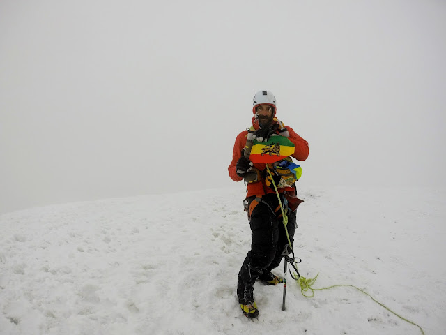
     The summit was socked in by fog, so there were no stunning views, no open vistas, no perspective of height. But that's okay with me. My adventures are very much an internal experience to a great degree, and the summit I was standing on in my mind had a clarity that the physical one lacked. We set the camera up on a timer and took some summit shots for fun and posterity. Including Heather a couple of days before, three Altra AmBadAssadors had stood on the summit of Mount Rainier within a 48 hour period. Not bad for a running shoe company.

photo by Ras/UltraPedestrian.com
Living Rastafari informs every aspect of who and what I am, and I was proud to stand on the highest point in the lower 48 US states as a Rastaman. As much as Mount Rainier is a giant antennae, this was a unique opportunity to broadcast some positive vibes around the world.

photo by Ras/UltraPedestrian.com
One of Kathy's Trail Totems frost rimed on the summit of Mount Rainier.

photo by Ras/UltraPedestrian.com
Seven Hills Running Shop has a unique vision for its team and the running culture that they promote. The shop is represented by innovative adventurers, climbers, and thru-hikers as much as it is speedy runners, and I'm proud to be a part of such a unique collection of Hominids.

photo by Ras/UltraPedestrian.com

     After making the summit, all we had left was the question of the Emmons Glacier Route. When Richard checked in at the Climbing Ranger station at Camp Muir he was again met with pessimistic route beta, and I knew that he still thought there was a good chance it wouldn't go. Richard had only been part way up the Emmons before, and had been sidetracked when his group came upon a rope team that had taken a crevasse fall, landed on a narrow ledge, and had overnighted in the crevasse. After calling for help via cellphone and waiting for it to arrive, Richard's party had descended once again to Camp Sherman and given up their summit bid. So Richard had never been on the top end of the route and wasn't familiar with it.

     When we were melting snow we agreed that we would give it a shot, and that worst-case scenario, we would have to climb back up and descend by the D.C. But almost as soon as we started down the Emmons Glacier Route we saw three ropes of climbers heading up toward us. We talked to the front rope and they assured us that the route was fine. Not only was there a clear route through the crevasses and the snow bridges were solid and safe, but they had made a boot track we could follow, had wanded the route, and had set pickets for protection on the sketchiest snow bridges.

     Richard was stoked to finally get some optimistic route beta, but he was still feeling the pressure of leading a novice (me) on this route, so he wanted to keep moving and make it over the sketchiest of the snow bridges before the day warmed up, so we were immediately off. I was moving much better on the descent than I had been on the ascent by a long shot, so we made good, consistent progress. after we had dropped down a couple thousand feet the fog and cloud lifted and absolutely stunning views surrounded us. 


photo by Ras/UltraPedestrian.com

     The more the sky cleared, the more beauty was revealed surrounding us. We were immersed in frozen visions of violent upheavals, the ghostly glacial blue in the depths of crevasses, the deep dark blue of the high altitude sky, and the brown-stippled white of snow with bare rock protruding through it. It was an amazing place to move through, a beautiful and moving place of movement. So move we did. As much as we had moved relentlessly up the previous day and evening and morning, the remainder of this miniature eternity would be spent in descent. 

photo by Richard Kresser/RunningFarther.com

     My emotions lifted and my spirit soared as the realization finally began to dawn on me that I had stood on the summit of the same mountain upon which my paternal grandfather had previously stood. Pa, as I called him, had passed away when I was still a boy, and I only remember meeting him a few times. One of those times he had bitten me on the nose, although in retrospect I suspect it was meant to be playful and was more of a gumming than an actual bite. But that's one of the few memories I have of him. And now we share The Mountain, and it's one of the few experiences I have to connect me to him.


photo by Ras/UltraPedestrian.com

     Not only that, but our traverse was going. The Rainier Wonder Route would not be completed, not by us, not this day or the next. But we were putting up a nice test piece for anyone who wants to hurl themselves at the mountain an unnecessarily difficult way. The further we descended the more sure a thing this became. And when Camp Sherman came into view and we could sight out the route all the way down, the time for reserving our elation came to an end. We no longer had to reign in our hopes, but could accept that we had achieved a major accomplishment, blurring the lines between mountaineering and adventure running, while only catching a fleeting glimpse of our own limits.

photo by Ras/UltraPedestrian.com

     As we descended the day was warming up considerably. I had stopped up high to take off my wool shirt, no longer needing it. By about the halfway point I had stopped again to remove my gloves and puffy jacket, and I had my down pants pulled up above my knees for ventilation. The heat had held off just long enough for us to make it past the most dangerous of the snow bridges. I could sense Richard relaxing as the question marks of our project were resolved, and as the burden of his responsibility for his own well being and mine was lifted from his shoulders.

photo by Ras/UltraPedestrian.com

     When we hit Camp Sherman we were both sweating in the warmth of the day. Even though cloud cover had rolled back in, the effort of moving in soft snow wearing heavy climbing boots and crampons was warming us from the inside faster than we could cool. We both traded our puffy pants for running shorts and an odd hybrid kit of ultrarunner meets mountaineer: short sleeve tech shirt, glacier glasses, helmet, ice ax, harness, boots and crampons. We would continue to travel roped up down the Inter Glacier until we reached Glacier Basin, as there was still the potential for crevasse falls, albeit slight.

photo by Ras/UltraPedestrian.com


     From Camp Sherman on down the mood was triumphant, light-hearted, and even playful. We ran down the soft steepness of the Inter Glacier, plunging down in big, heavy-footed strides like video footage of astronauts walking on the moon played at high-speed fast forward. We dropped to our butts and glissaded seated for hundreds and hundreds of feet. It struck me that there was an odd, and perhaps childish, symmetry to this: at the beginning of our trip the White River had forced us to drag our asses across a log to begin our journey, and now we were ending it by dragging our asses across the very headwaters of the White River itself. Poetic? Perhaps not. But at that point I was more than willing to accept whimsy in place of poesy.


photo by Richard Kresser/RunningFarther.com

     When finally we reached the end of the Inter Glacier and switched out our climbing boots for trail running shoes once again, we knew we had reached the completion of the circle in every sense. In our burdened and ungainly manner we trotted out the last few miles to the White River Campground. As often happens at the conclusion of epic adventures, we passed scores of dayhikers, car campers, and tourists, none of whom suspected what we had just done. To a degree it was already becoming a secret thing, an experience that, no matter how much we talked about it, no one could truly grasp without setting foot to trail and actually doing it.

     In the end, including roughly 18 hours spent doing nothing at Camp Muir, it took us 54 hours and 32 minutes to establish the Only Known Time for what I am calling the Cowlitz Connection Route. Comprising some 50 miles and 17,000 feet of elevation gain the Cowlitz Connection is a solid undertaking. But, as I've said before, an Only Known Time is the Schroedinger's Cat of FKTs. It exists simultaneously as both the Fastest and Slowest Known Time for a route, and our time is decidedly at the slow end of the spectrum. Had we not had our sights set on an even grander endeavor, had we set out specifically and only to do the Cowlitz Connection we could easily have taken twelve hours off our time. But it is what it is, and I'm extremely stoked that we were able to overcome so many challenges and stumbling blocks and accomplish what we did.

     My heartfelt thanks goes out especially to Richard Kresser for taking a big risk on the crazy idea of an inexperienced fledgling mountaineer. I look forward to attempting another adventure together that's at least as ridiculous in scope and ambitious in intent as this one was.

     And for all that, the Rainier Wonder Route is still on the table. I don't know when or if I'll attempt it again. I have another idea for a unique double circumambulation of the Mountain that I need to start researching. Plus there's Chad Kellogg's Infinity Loop Route, of which I only learned recently. It's above my skill level at the moment for sure, but I know my brain is going to have trouble letting go of that idea anytime soon. And, in the end, for me, that's what it's all about. The mental mastication, ingestion, and metabolism of an idea that leads to the eventual excretion of the adventure itself. And if you followed my metaphor closely you'll notice the previous sentence ended with both a period and a colon.

     What a Blessing to be a Hominid! Give Thanks for Life!  


photo by Ras/UltraPedestrian.com

Gear List:Altra Lone Peak 2.0 trailrunning shoes
Zensah Calf Sleeves
Western Mountaineering puffy down pants
Western Mountaineering puffy down jacket (didn't use)
Montbell synthetic puffy jacket
Pendleton button-up long sleeve wool shirt
Darn Tough hiking socks, 1 pair
Injinji Trail 2.0 Midweight Mini-crew toesocks, one pair
North Face gore-tex shell
Black Diamond Gloves
Black Diamond Ice Ax
Black Diamond Polar Icon Headlamp

Black Diamond Ultradistance z-poles
Black Diamond Coulior Climbing Harness

3 locking carabiners, 3 standard carabiners, 2 slings, 2 prussiks, 1 pulley
Outdoor Research Gaiters
Petzl Crampons
WAA UltraBag Pack with two 1 liter bottles
Salewa Boots
Julbo glacier glasses
Altra tech shirt
Team 7 Hills jersey (didn't wear)
REI merino wool glove liners (didn't wear)
Dirtbag Runners bandito
Fleece camo hat
Fleece UltraPedestrian hat
2xU running shorts
Platypus Unbottle 2 Liter
Pendleton Wool Shirt
REI ultralight 10 liter Drysack, two
webbing strap with buckle for attaching drybags to pack, two
SPOT Transponder
Sony Walkman mp3 player
Asio Altimeter watch
pre-charged portable charger
6' duct tape wrapped around each trekking pole, 12' total


photo by Ras/UltraPedestrian.com